Key Highlights
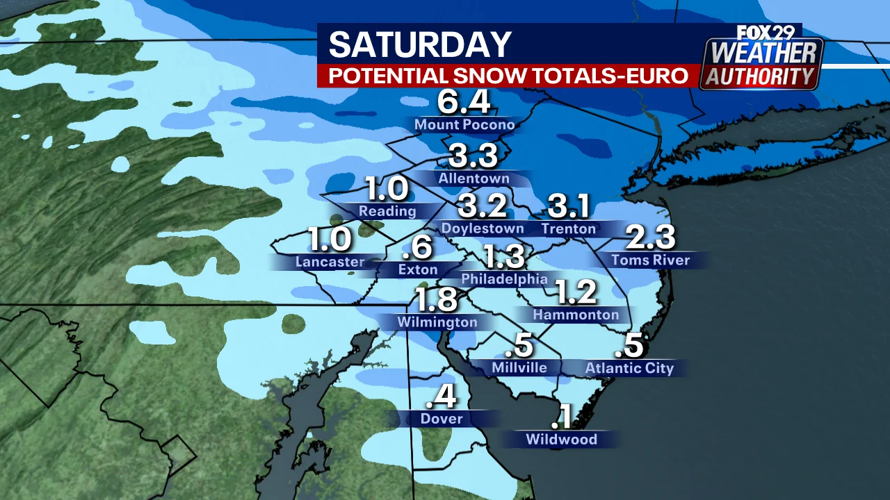
- A winter storm is expected to bring several inches of snow and sleet to the Philadelphia area over the weekend after Christmas.
- The National Weather Service issued winter storm watches for Eastern Pennsylvania and New Jersey north of Camden County.
- Philadelphia will start seeing sleet around 5 p.m. or 6 p.m. on Friday, with a mix of snow, sleet, and freezing rain expected throughout the region.
- The potential for significant snowfall has raised concerns about dangerous travel conditions over the holiday weekend.
Christmas Weekend Snowstorm Looms Over Philadelphia Area
A winter storm is on track to bring several inches of snow and sleet to the Philadelphia area, complicating holiday weekend travel plans for residents. The forecast, issued by FOX 29 meteorologist Sue Serio, suggests that the region should brace for a mix of weather conditions, including snow, sleet, and freezing rain.
According to Serio, the storm is expected to begin its journey across Eastern Pennsylvania and New Jersey on Friday afternoon. “What you get (snow, sleet, or freezing rain) depends on where you are,” she noted, emphasizing the variability of weather conditions based on location.
The Storm’s Path and Impact
Starting around 5 p.m. or 6 p.m., Philadelphia residents can expect to see a shift in the weather pattern towards sleet, with varying degrees of snow expected as well. This mix of precipitation will add to the complexity of travel plans over the holiday weekend.
“The storm is moving from the west to the east,” Serio explained. “This means that South Jersey and Delaware are likely to see rain by Friday night.” The meteorologist’s prediction highlights the importance of staying updated on local weather reports as conditions change rapidly during a winter storm event.
Travel Warnings and Safety Tips
The National Weather Service has issued warnings about potential ice accumulation, which could make roads dangerously slippery. “People ‘should consider delaying all travel’ until after the winter storm is over,” advised the NWS, adding that if travel becomes absolutely necessary, drivers should proceed with extreme caution.
“Drive with extreme caution” was repeated as a critical safety message for those who must venture out during the storm. The weather service recommended bringing safety kits and other supplies in case of getting stranded on the road due to poor conditions. These precautions are crucial given the potential for significant snowfall, which could vary from one location to another within the region.
Regional Preparedness
In anticipation of the storm, New Jersey has declared a state of emergency, highlighting the seriousness of the situation and the need for comprehensive preparation. The announcement underscores the potential impact on local infrastructure and services, particularly in terms of transportation and public safety.
“The chance of seeing 4 inches of snow or sleet is nearly 30% in Philadelphia by Saturday morning,” according to Serio. “These chances increase to as high as 63% just 30 miles north in Trenton.” This localized variation in weather predictions necessitates that residents pay close attention to local advisories and updates from meteorologists.
With the holiday weekend approaching, many are preparing for potential disruptions caused by the storm. The combination of snow, sleet, and freezing rain poses significant challenges for both drivers and pedestrians alike.
As the storm moves through the region over Friday into Saturday, it is essential to remain vigilant and prepared for changing weather conditions.
The forecast highlights the importance of staying informed about local weather updates and taking necessary precautions to ensure safety during this winter storm event. Whether you are planning a trip or simply need to venture out, consider the potential impacts of the weather on your travel plans and take appropriate measures to stay safe.