Key Highlights
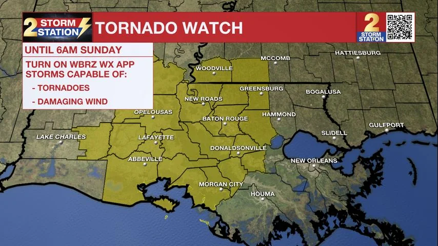
- A Tornado Watch remains in effect for several parishes and counties in central Louisiana until 6 a.m. on October 27, 2025.
- The main line of thunderstorms is expected to move through the Capital Area between 2-5 a.m., with potential severe weather concerns.
- Residents are advised to prepare for possible tornadoes and strong winds, especially in East Baton Rouge, West Baton Rouge, Ascension, and surrounding parishes.
- The approaching storms could bring up to 3 inches of rainfall, benefiting local areas but potentially causing flash flooding if it falls too quickly.
Storms Moving Closer: Tornado Watch Issued for Central Louisiana
A persistent line of severe storms is inching closer to the Capital Area in central Louisiana, prompting a Tornado Watch that remains in effect until 6 a.m. on Sunday, October 27, 2025.
Current Storm Activity and Warnings
As of early morning on Saturday, October 26, 2025, scattered showers have been moving through the region, but the main line of thunderstorms is still west of Baton Rouge. The strongest storms so far have been on the southern flank of this line.
A number of Severe Thunderstorm and Tornado Warnings were issued in southwest Louisiana over the past few hours. Damage caused by a tornado was reported in Sulphur, LA. While some signs indicate that these storms may be weakening, the National Weather Service continues to emphasize the need for caution as conditions can change quickly.
Projected Storm Path and Impact
The line of storms is forecasted to move through the Capital Area between 2-5 a.m., potentially bringing with it severe weather concerns. The National Weather Service has issued a Tornado Watch for East Baton Rouge, West Baton Rouge, Ascension, Assumption, Iberville, East Feliciana, Livingston, Pointe Coupee, St. Helena, St.
James, St. Mary, and West Feliciana Parishes, as well as Amite and Wilkinson Counties.
Residents are advised to stay vigilant for threatening weather conditions and listen for further statements and possible warnings. If a tornado warning is issued, seek shelter in a low-level, interior room of a sturdy building. Pet owners should bring their pets (on leashes) with them, wear hard-soled shoes, monitor storm coverage on a wireless device, and cover their heads to protect against potential wind or tornado impacts.
Preparation and Safety Measures
The approaching storms are expected to drop an additional 1-3 inches of rain in the Capital Area. While this should provide a beneficial soak for most locations, some areas may experience higher rainfall totals, increasing the risk of flash flooding if it falls too quickly.
While overnight showers and storms may linger into the early morning hours on Sunday, rain is expected to move out quickly after sunrise. The afternoon is forecasted to bring only spotty thunderstorms with temperatures around 80°F. By Monday, a strong cold front will drop daytime highs into the 60s and lows into the 40s by the end of the week.
Hurricane Melissa: A Major Threat in the Tropical Atlantic
While severe weather is on the horizon for central Louisiana, the Tropics also pose a significant threat. Hurricane Melissa rapidly intensified into a major hurricane on Saturday evening while moving westward just south of Jamaica. Intensification will continue, with forecasters predicting that Melissa might be a Category 5 storm by Monday.
The storm is expected to turn north toward Jamaica, where landfall looks increasingly likely over the next few days.
A multi-day period of damaging winds, heavy rainfall, and storm surge is anticipated, leading to catastrophic flash flooding and numerous landslides. After impacting Jamaica, Melissa will track toward eastern Cuba, the southeastern Bahamas, and the Turks and Caicos Islands.
Residents in affected areas are advised to monitor weather updates closely for the latest information on evacuation routes and safety measures. The National Weather Service provides real-time updates and a 7-day forecast to help individuals prepare for potential impacts from both the approaching storms and Hurricane Melissa.
Your Local Weather Station: Keeping You Informed
The Storm Station, in collaboration with local news outlets like WBRZ, remains committed to providing accurate weather information. Follow updates on their official website at wbrz.com or through the WBRZ WX App available for both Apple and Android devices.
For more detailed weather coverage, including breaking news and live updates, visit wbrz.com or tune in to News 2 for comprehensive weather reporting. Stay connected on social media platforms like Facebook and X for real-time alerts and additional resources.
Remember, the safety of your loved ones is paramount during severe weather events.
By staying informed and prepared, you can minimize risks and ensure a safer environment for everyone involved. For more information on tornado safety, visit the National Weather Service’s official website or click HERE.