Key Highlights
- Snow chances for the Upstate of South Carolina on Sunday morning are confirmed by local meteorologists.
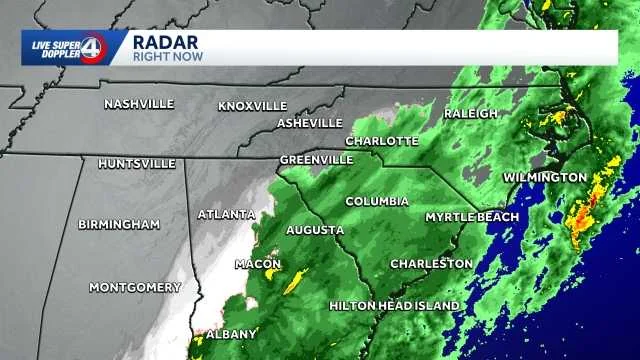
- Precipitation is expected to transition from rain to snow between 7 a.m. and 11 a.m., with accumulation limited to less than an inch.
- Areas like Asheville, Greenville, Spartanburg, Anderson, Athens, Atlanta, Charlotte, Columbia, Rock Hill, Statesville, and Mooresville should prepare for minor impacts due to potential flurries.
- The event is described as a low-impact weather system with minimal travel concerns.
Sunday Snow in the Upstate: A Brief Overview
Weather enthusiasts in South Carolina, North Carolina, and Georgia have been keeping an eye on the forecast for Sunday morning. According to local meteorologists like Grace Lowe, a brief rain-to-snow mix is possible across the Upstate of South Carolina starting at 7 a.m., with an accumulation expected to be less than an inch.
The timing of this event has been closely monitored by weather stations and experts, who are using tools such as live cameras and advanced model data to provide accurate updates. As of Sunday morning, flurries have already been spotted on the Paris Mountain live camera operated by WYFF 4 News.
Impact and Preparations
Meteorologists predict that while some areas might see snowfall, it is likely to be a light event with minimal travel disruptions. High temperatures are expected to range from the low 40s in the Upstate to the low 30s in mountain regions. The weather system will last through 3 p.m., and cold conditions will continue into the evening.
As of Sunday afternoon, Chief Meteorologist Chris Justus emphasized that while there is a possibility of snow, the event remains a minor one with limited accumulation expected.
He noted that the models are still in flux and additional updates will be provided as more data comes in. Areas like Asheville, Greenville, Spartanburg, Anderson, Athens, Atlanta, Charlotte, Columbia, Rock Hill, Statesville, and Mooresville should prepare for flurries but not to expect significant snowfall.
For residents in these areas, the primary concern is minor impacts such as slippery surfaces on grass and elevated areas. Local authorities are advising minimal travel during this period to ensure safety.
Expert Analysis
Meteorologist Bradford Ambrose from WYFF 4 News highlighted that a Live Super Doppler 4 Impact Day has been declared for Sunday due to the potential for measurable snow, particularly in areas southeast of I-85. He noted that cold air will catch up with the precipitation, creating the best chance of seeing snow between 7 a.m. and noon.
The accumulation is anticipated to be less than one inch, primarily accumulating on elevated surfaces such as decks and lawns. Chris Justus also pointed out that while there could be a narrow deformation band enhancing snowfall in certain corridors like I-77, the likelihood of significant higher amounts remains low at 1–2 inches.
Overall, meteorologists are advising residents to stay prepared but not overly concerned about major travel disruptions. The event is being closely monitored, and updates will continue to be provided as conditions change throughout Sunday.
This article provides a comprehensive overview of the upcoming snowfall event in the Upstate region, based on detailed forecasts and expert analysis from local meteorologists.