Key Highlights
- A Winter Weather Advisory is in place for parts of Warren, Butler, Ohio, Franklin, and Union counties from 7am Saturday until 9am Sunday.
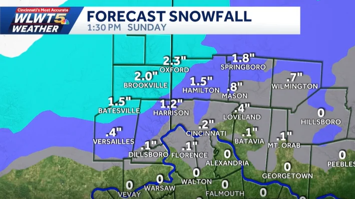
- Snowfall totals are expected to be trace to two inches, with better chances in northern Kentucky, south-central Ohio, and areas northwest of the I-275 loop.
- Freezing temperatures will lead to slick spots on roadways, especially overnight into Sunday morning.
Winter Weather Advisory: A Trace to 2 Inches Possible for Areas Across Cincinnati
All right, let’s check in with meteorologist Adam Burniston. While we are getting some flurries, there’s no need to worry about anything too severe. The system coming from the west will bring a mix of rain and snow, making it tricky to predict exactly how much snowfall we might see.
Tracking the Snow
We’re tracking this winter weather advisory for parts of Warren, Butler, Ohio, Franklin, and Union counties in Ohio state, as well as areas in Indiana. The advisory will be in place from 7am to 9am on Sunday. While we won’t see significant impacts until after sunset, some snow showers might still occur through the early afternoon hours in northern parts of our area.
The main impact is expected during Saturday night and into Sunday morning when heavier bands of snow could stretch further south.
However, the accumulation will be much less across northern Kentucky, south-central Ohio, and around Cincinnati due to mixing with rain. The best chances for accumulating snowfall are in areas northwest of I-275.
Freezing Temperatures and Road Conditions
The freezing temperatures overnight into Sunday morning could lead to some slick spots on the roadways, especially if any snow does stick to the pavement. Additionally, as this system moves off by early Sunday, we will start seeing rain, which could melt accumulated snow.
Temperatures are expected to drop into the lower 20s by Sunday morning and climb through the mid to upper 30s during the afternoon and evening. This temperature fluctuation is contributing to the mixing of rain and snow as well. By Monday and Tuesday, another winter weather maker will move in, providing another shot at accumulating snowfall.
Precautions for Weekend Travel
Residents should be cautious when traveling, especially on roadways where freezing temperatures can create icy conditions. Even with the possibility of a light coating of snow, slick spots are likely to occur. Make sure to check back for more updates as the situation evolves.
In summary, while there is a chance for some snow this weekend in the Cincinnati area, most areas will see minimal accumulation due to the mixing of rain and snow. Freezing temperatures overnight could create slick spots on roads, so stay informed and be prepared for changing weather conditions.